Roman times
In Roman times the River Thames was crossed by a wooden bridge 60 metres east of where London Bridge now stands. (More information here.) The Roman road, Stane Street, leading directly to that place came up from the south from the direction of Chichester via what is now the Elephant and Castle and Borough – a route followed by the A3 road today.
Van Diemen’s Land
Old Kent Road and Tabard Street – which runs from the flyover to Borough alongside Great Dover Street – were originally one road (just called Kent Road) and follow another Roman road, Watling Street. This came from Dover via Canterbury – the route of the present A2. Another Roman road, from Lewes in East Sussex, joined Watling Street at the Asylum Road junction with Old Kent Road (by Toys’R’Us). Watling Street joined Stane Street at Borough.
Although this area was all countryside at the time it was, of course, a very important route between Londinium and Rome, and McDonalds (on the Cantium Retail Park between Asda and B&Q) is on the site of a Roman villa.
Middle Ages
The main local features of the area in the Middle Ages were:
- Bermondsey Abbey (which, at one time was a powerhouse equal to Westminster but which no longer exists, having been pulled down to build a mansion in the reign of Henry VIII) and
- the pilgrim route to Canterbury after the murder in Canterbury Cathedral of Thomas Becket on 29 December 1170.
| The pilgrim route, immortalised in the late 1300s by Chaucer in the Canterbury Tales, was one of the major pilgrim routes in England. You can still see the occasional pilgrim following in their footsteps down the Old Kent Road.
Between Shorncliffe Road and Albany Road, opposite Tesco, was a hostelry where the mediaeval travellers would stop and water their horses. It was called St Thomas a Watering, later to become the Thomas a Becket pub and was a place of public hangings. According to ‘The Old Kent Road, Old and New London: Volume 6′ by Edward Walford published in 1878, which contains a lot more information about this area, the last people hanged there were a father and son, for murder, in 1740. |
Canterbury Tales The reference to the Tabard Inn in Southwark (near London Bridge) comes early in the prologue to Chaucer’s Canterbury Tales. You can enjoy listening to it read in its original Late Middle English, with notes, on the Luminarium site (It’s brilliant.)
|
There is an ancient tradition of hanging criminals at crossroads outside the town or city so that their spirits would be confused as to which way to go back.
Old Kent Road Pubs
In the 19th century and early 20th century the Old Kent Road, with its market (which moved to East Street when tram lines were put down the OKR) was a famous drinking place. 15 pubs are shown in the half mile of Old Kent Road shown on the 1894 Ordinance Survey map of the area (reproduced by Godfrey Maps: London Sheet 90, ISBN 0-85054-033-X, purchase online or in East Street Library). A few survive as pubs, some have been put to other uses, and some demolished.
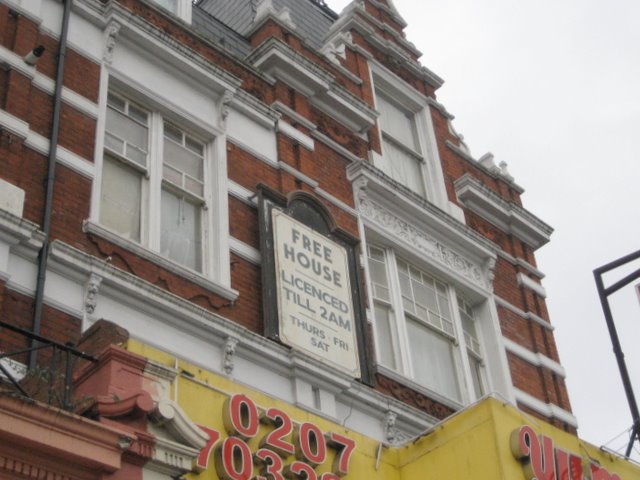
The Trafalgar, still a pub, a little further out on Old Kent Road.
The Green Man, now converted on the ground floor to a restaurant, has a history going back to the 18th century when a turnpike (toll booth) crossed the road between it and the Dun Cow.
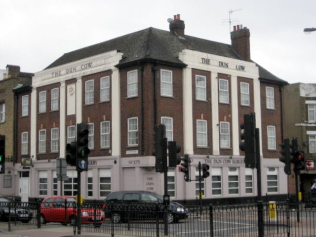
The Dun Cow‘s present 1930s (50s?) building is now a doctors’ surgery. ‘Dun’ is a brownish grey colour, and dun horses classically have a dark stripe along the top of their backs, but our Dun Cow is a much more interesting animal!
The Dun Cow is a mythical beast which, like the gryphon, phoenix and unicorn, was used as a royal emblem by Henry VII and his son Henry VIII. They adopted the Dun Cow because it because was associated with the earls of Warwick. Henry VII executed Edward Plantagenet, the last Earl of Warwick, in 1499 to remove a potential rival claim to the throne which he had snatched from Richard III. In Warwick castle there is a large narwhal tusk which people used to believe was a rib of the Dun Cow. Logically, therefore, the cow must have been huge, and so the legend grew. It was said to have given copious amounts of milk until a wicked woman tried to play a prank on it with a sieve instead of a bucket. When the cow realised that its milk was being wasted on the ground it took off in a rage. The rampaging cow was killed by Guy of Warwick – also legendary – who was reputed to have defeated the Danes. In a further twist, it has been suggested that the name ‘dun cow’ has evolved from ‘dena gau’, the German for ‘Dane region’, but that is probably pushing it. (See Wikipedia Dun Cow). What is more clear, however, is that as the legend of the Dun Cow spread, perhaps promoted by its royal connections, other large bones around the country, such as whale jawbones, became associated with the story and a number of pubs took the Dun Cow name. (Photos.) It could be owing to the association of inexhaustible liquid refreshment – or it could have just made a change from calling them The Red Lion!
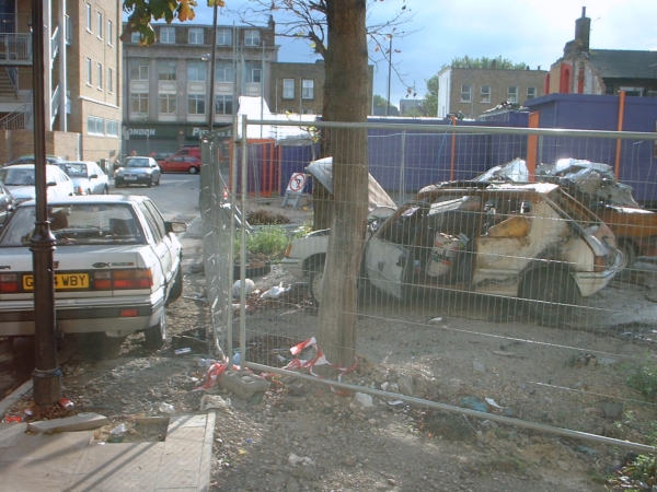
The Castle/The Gin Place was on the corner of Marcia Road and Old Kent Road where Marcia Court now stands. There was a pub called The Castle apparently shown on this spot on a map from 1745 – long before the surrounding houses were built. According to the ‘Pubs History’ website, it was named from Oliver Cromwell’s fort nearby. The name was changed to the Gin Palace in only about 1985. There are two old photos of The Castle on the PubWiki site. (Thanks to Chris of the Lyons Family website, above, for the link.)
The only photo I have is of the site during demolition in 2002. The white wall in the centre is part of the front wall, and the red-painted alcoves, top right, part of the upper interior. The two burnt-out cars are where the houses 3A-C now stand, and in the background is the building now converted into the Eurotraveller Hotel.
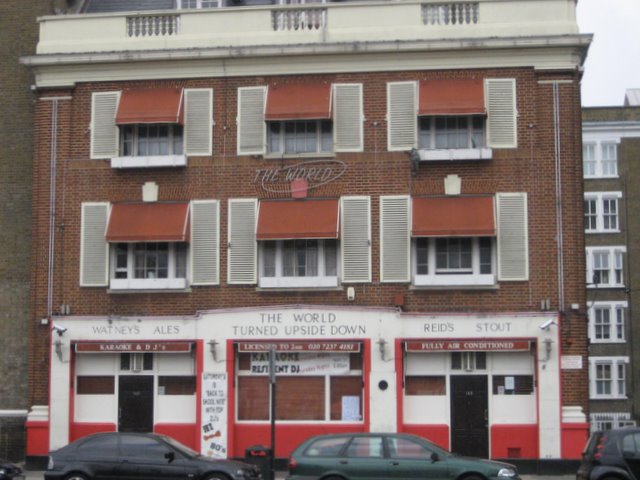
The World Turned Upside Down, towards the Old Kent Road flyover, was once the ‘home’ pub of London’s London’s Pearly Kings and Queens. It is also mentioned in Edward Walford’s history (see above) as already being over 200 years old when the book was published in 1878. In it he reports the name as originating either from the discovery of Australia, Van Diemen’s Land, or Terra del Fuego or from the practice of inn sign makers to depict “things the opposite of what is natural and usual”.
The Bricklayer’s Arms, now demolished, is only remembered in the name of the bus stop near the flyover. The huge railway terminus (now the Mandela Way business park – see the description higher up the page) was named after the pub.
![]()
Eighteenth and nineteenth century
[to be completed]Notes:
Penry Street, that links Marcia Road and Old Kent Road (used to be called Northampton Street) but, at some point, was named after “an important religious dissident in the time of Elizabeth I who was taken to the gallows – opposite Tesco – where there was also a gibbet to hang up dead people as an example to potential sinners and heretics.” (Robyn Conway)
Nearby Hendre Road was named after the Rolls’ family’s home just outside of Monmouth, Wales.
Burgess Park / canals / Ice house / Deaf and Dumb school/ trams/ etc.
http://web.archive.org/web/20160319120705/http://londoncanals.co.uk/grsurrey/gsc08.html